

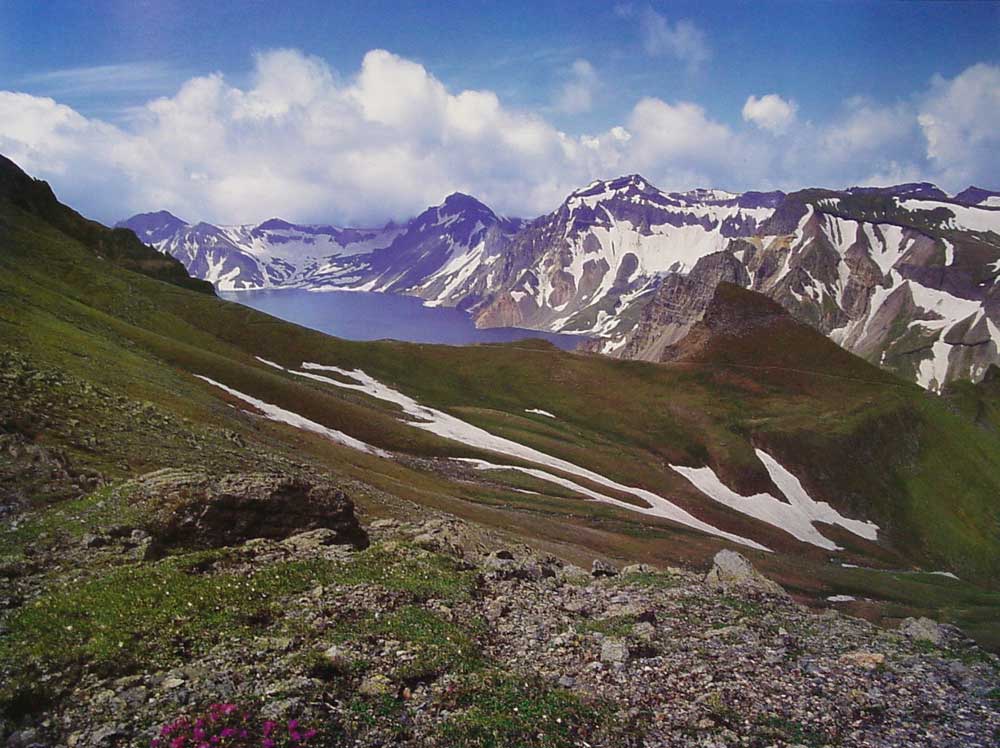

Baekdu Mountain is a volcanic mountain on the border between China and North Korea, located at . At 2,750 m, it is the highest mountain of the Changbai Mountains to the north and Baekdudaegan to the south. It is also the highest mountain in Korea and Manchuria.
The Korean name means "white-headed mountain". It is called Changbai shan in Chinese and Golmin Šanggiyan Alin in Manchu, both meaning "perpetually white mountain".
One of the highest crater lakes in the world, called Chonji, lies at the top of the mountain.
The central section of the mountain rises about 3 mm every year, due to rising levels of magma below the central part of the mountain. The highest peak is called Janggun Peak, covered in snow about eight months of the year. The slope is relatively gentle until about 1800 m.
Sixteen peaks exceeding 2500 m surround Chonji. The crater lake was probably created in 1597, when a recorded eruption took place. Ashes from this eruption have been found as far away as the southern part of Hokkaido of Japan. The lake has a circumference of 12 to 14 kilometres, with an average depth of 213 m and maximum depth of 384 m. From mid-October to mid-June, the lake is covered with ice.
Water flows north out of the lake, and near the outlet there is a 70 meter waterfall. The mountain is the source of the Songhua, Tumen (Tuman) and Yalu (Amnok) rivers.
Climate
The weather on the mountain can be very erratic. The annual average temperature at the peak is about -8.3 degrees Celsius. During summer, temperatures of about 18 degrees Celsius can be reached, and during winter temperatures can drop to -48 degrees Celsius. Average temperature is -24 degrees Celsius in January, 10 degrees Celsius in July, remaining below freezing for eight months of the year. Average wind speed is 11.7 meters per second, reaching an average of 17.6 m/s in December. Relative humidity averages 74%.
Flora and fauna

There are five known species of plants in the lake on the peak, and some 168 were counted along the shores. The area is a known habitat for tigers, bears, leopards, wolves, and wild boars. Deer in the mountain forests, which cover the mountain up to about 2000 metres, are of the Paekdusan roe deer kind. Many wild birds such as black grouse, owls, or woodpecker are known to inhabit the area.
History
The Baekdu Mountain has been worshipped by the surrounding peoples throughout history. Koreans and Manchurians alike consider it the place of their ancestral origin.
The legendary beginning of Korea's first kingdom, Gojoseon (2333 BCE-108 BCE), takes place here (then called Taebaek Mountain). Buyeo, Goguryeo, and Balhae kingdoms also considered the mountain sacred. The Goryeo dynasty (935-1392) first called the mountain Baekdu, recording that the Jurchens across the Yalu River were made to live outside of Baekdu Mountain. The Joseon Dynasty recorded volcanic eruptions in 1597, 1668, and 1702. King Sejong the Great of Joseon strengthened the fortification along the Tumen and Yalu rivers, making the mountain a natural border with the northern peoples.
The Jurchen Jin Empire bestowed the title "the King Who Makes the Nation Prosperous and Answers with Miracles" (興國靈應王 Xingguo Lingying Wang) on the mountain god in 1172 and it was promoted to "the Emperor Who Cleared the Sky with Tremendous Sagehood" (開天宏聖帝 Kaitian Hongsheng Emperor) in 1193. During the Manchu Qing Dynasty, the Kangxi Emperor designated the Baekdu Mountain as the legendary birthplace of the imperial family Aisin Gioro followed a survey although it is no longer supported. He set a forbidden zone around the mountain, although it was still in dispute whether it was part of Korea (Joseon) or China. The Qing Dynasty held annual rites for the mountain, as did the earlier Jin Dynasty.
Because of the continuous entry of Korean people into Gando, a region in Manchuria that lay between the Tumen and Yalu Rivers, in 1712, Manchu and Korean officials built a monument describing the boundary at a watershed. The interpretation of the inscription caused a territorial dispute from the late 19th century to the early 20th century, and is still disputed by academics today. The current border was set by the 1909 Gando Convention between Qing and Japan, while Korea was a Japanese colony.
Dense forest around the mountain provided bases for Korean armed resistance against the Japanese occupation, and later communist guerrillas during the Korean War. North Korea claims that Kim Il-Sung organized his resistance against the Japanese forces there and that Kim Jong-il was born there, although it is likely that these took place a short distance within the borders of the Soviet Union.
Sightseeing
 Cheonji |  Waterfall |  Hot springs | |
 River |

Foreign visitors, including South Koreans, usually climb the mountain from the Chinese side, although Baekdusan is a common tourist destination for the few foreign tourists in North Korea.
There are a number of monuments on the North Korean side of the mountain. Paektu Spa is a natural spring and is used for bottled water. Pegae Hill is a famous camp site of the Korean People’s Revolutionary Army during their struggle against Japanese colonial rule. There are also a number of secret camps which are now open to the public. There are several waterfalls, including the Hyongje Falls which splits into two separate falls about a third from the top.


No comments:
Post a Comment